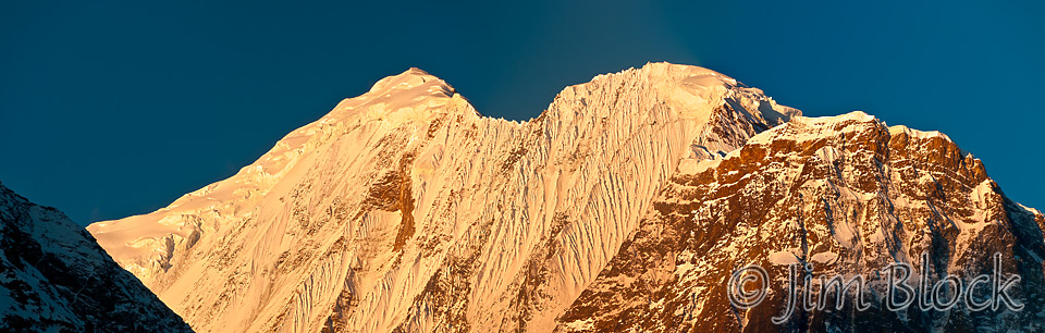
It is 5 AM and the start of a great day. The room is cold, but not bitterly cold. The blankets worked fine, with the sleeping bag. The mountains were beautiful as dawn arrived. I photographed them from my room and from the porch just outside my door. Here is the early light on Gangapurna.
Below is a photo of Annapurna II far down the valley. Tomorrow’s page will show an early morning photo of Annapurna III emerging from the fog.

-")
Except for Lisa being a bit under the weather, everyone is feeling fine and will remain that way the rest of the trip. I’m feeling great, eating better (more) than most anyone. I fear I might actually gain weight on the trip. Chhongba assured me I would not, and he was right. I lost some weight during the trip.
The menu for the hotel states “please order one hour before you want to eat” which is an honest assessment of a typical Nepali kitchen. This kitchen featured three young males, although only two were present for breakfast. Fortunately there were only a few others here these two nights. A very large group of people from France was expected right after we left.
After breakfast I had some time to wander the main “street” of Manang and photograph some shops, homes, and people before our hike. Here is a dwelling complex that I found visually interesting. I put a number of photos of the buildings of Manang where I have minimized the details to accentuate the forms on a Blog page. That page will open in a new tab if you CLICK THE IMAGE BELOW.

Here is a 6-shot panorama of a typical, though fairly large and well stocked, store.
")
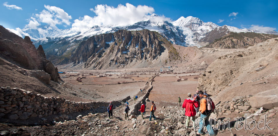
We took an acclimatization hike across the river to a spot called Chongkar viewpoint, 1000 ft above Manang and more than that above the Marsyangdi river which we crossed to get there. Our route took us across the valley and up a slope to an almost straight down view of Gangapurna Lake. For those interested in words, Gang means water or lake, purna means full, and Anna refers to crops.
Here we are leaving Manang. I have labeled the mountains, but you need to click this image to get to a site where you can zoom way in then pan around and read them. When you get there, click the double arrow above the image on the right to see it full frame. Please wait for the resolution to download. You can use the + and – keys to zoom and the arrow keys to scroll. Or use the scroll wheel to zoom and the left mouse to drag.
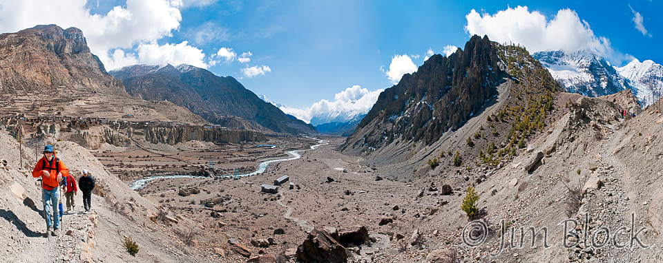
We crossed the valley and climbed up to a knife edge above Gangapurna Lake. Below is a 10-photo panorama from just before the knife edge. I have labeled mountains and the location of the rest of our group and the glacier on a version you can see if you click this image. When you get to the new site, click the double arrow above the image on the right to see it full frame. Please wait for the resolution to download. You can use the + and – keys to zoom and the arrow keys to scroll. Or use the scroll wheel to zoom and the left mouse to drag.
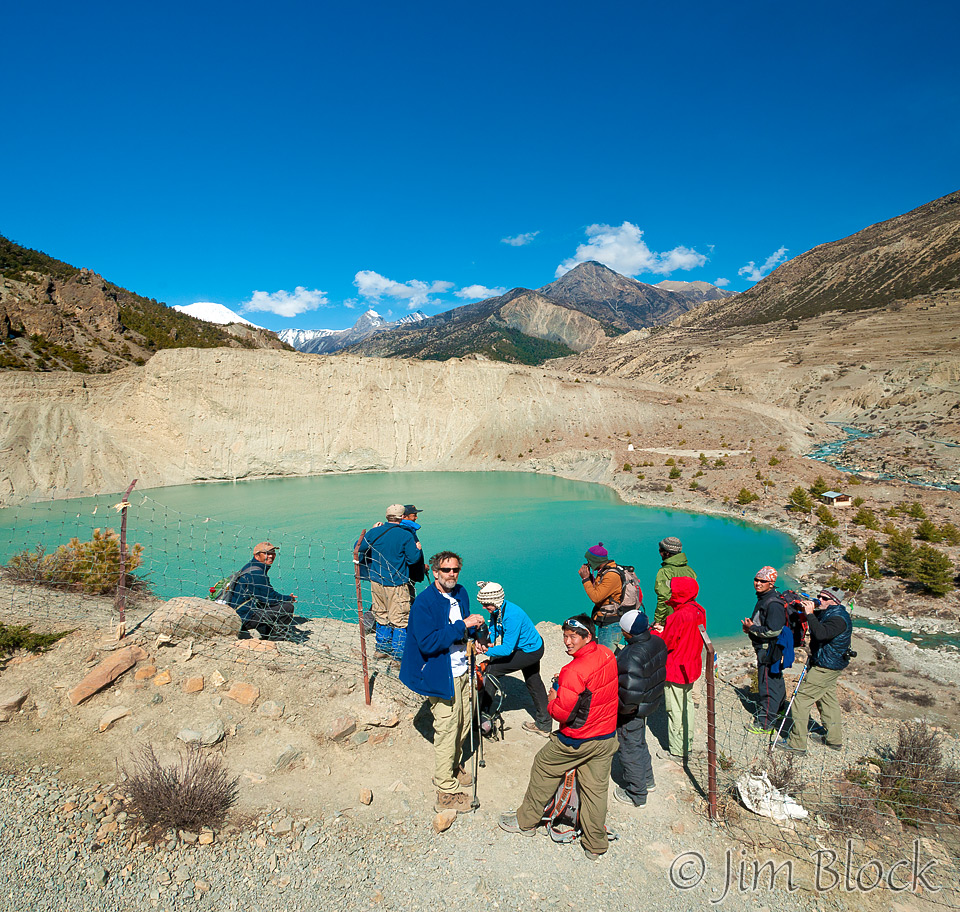
Here we are above the lake. The fence was already down when we got there.
I put some photos of Gangapurna Lake in a Blog Post that you can open in a new tab if you CLICK HERE.
We climbed up a steep switch-backed trail to the viewpoint and got a great close up view of the Gangapurna icefall. We convinced someone to take a group photo with Gangapurna and its glacier in the background.

I took it very slowly coming back down because I had learned that I needed to baby my strained left calf. So I got far behind, which made for some nice photos of our group with Gangapurna Lake in the background. Here is an overview photo, others are in the slide show at the bottom of this page.
The mountain in the middle with snow is Tilicho Peak. We will pass well behind it in several days. Additional photos of Gangapurna Lake are in the slide show that follows. I also did a special tribute to the beautiful Gangapurna Lake on a Blog post. You can view it in a special tab by simply clicking the image below.

In the afternoon, part of our group attended a lecture at the clinic in Manang and learned that one of the risk factors for altitude sickness was being under 50. Must be why I have done well avoiding it! Remember the young Israeli group we saw the day before in Humde? Well, being young (well under 50), they pressed ahead to far, too fast, and too high. One of them collapsed and had to be brought downhill tied to a horse to the clinic at Manang. When he reached Manang he could sit but not stand. We watched a helicopter pick him up from the buildings with the blue roofs in the center of this photo and take him to Kathmandu. We were told later that, once at lower elevation, he revived and was doing well. Getting down and into thicker air is the best cure for altitude sickness — if you can do it soon enough.
You can see the buildings I am referring to as well as our hotel, also with blue roofs, which is to the left of the the blue-roofed compound on the cliff, if you can click this image and get to a site where you can zoom way in then pan around. When you get there, click the double arrow above the image on the right to see it full frame. Please wait for the resolution to download. You can use the + and – keys to zoom and the arrow keys to scroll. Or use the scroll wheel to zoom and the left mouse to drag.
The village of Manang stretches out to the left of our hotel.
")
After lunch we presented the porters and sherpas with fleece from Leeli, sock we bought for them, and other pieces of apparel that would help them over Thorung La with minimal discomfort.


In the afternoon, the conscientious ones in our group went to get our vital signs and oxygen content checked at the local clinic and hear lectures on altitude sickness. The less conscientious of us grabbed a camera and wandered around the old part of Manang.
Old Manang was absolutely spectacular: old structures of stone and wood, narrow walkways, animals at every turn. Parts of old Manang still had leftover snow from the winter in the shielded court yards. The slide show at the bottom of this page has many photos from old Manang as well as photos of the people and children of Manang.


As I saw in Chame and other towns, much of the transporting of heavy stones is done by women. The men load their backboards, and the women carry the rocks. Children in Manang use the backboards as pretend cars, although it is likely they have never seen a car in person.
In the slide show at the bottom of this page, portraits of the men and women involved with the rock moving and wall construction follow the photos of the rock carrying.
In Manang, as in most of the towns along our trek, ladders were carved out of long logs as can be seen in the photo below.")
I put some simplified photos of Manang in a Blog Post that you can open in a new tab if you CLICK HERE.
Manang had several movie theaters. One is shown below. I was not tempted to check them out. So much to do, and so little time to do it.
")
Please don’t miss the slide show below.

")
")


")
-")
")
-")
")
")


")


")


-")


![]()