The mountains were amazing from the Yeti Hotel in Manang as daylight broke through early morning fog. I made some photographs from my room, but mostly I took them from the balcony just outside my door. This one was taken from my room.
")
The Yeti Hotel was a wonderful place. Although it discouraged washing in your room (“in the toilet”), they provided lines outside the rooms to hang wet clothes.

Leaving Manang through the old city, we soon arrived at a spot with fantastic views of Gangapurna Lake. In the photos below you can see the knife edge above the lake where we walked the day before. After the knife edge, we zig-zagged up the slope above it to get to a great spot to view the Gangapurna glacier above the lake.


In the distance, the village of Manang was backlight. The dramatic clouds gradually dissipated throughout the morning then returned in the afternoon.
")
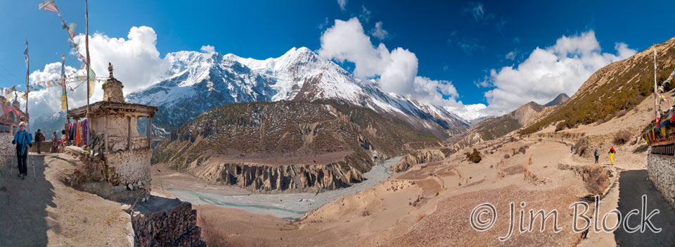
Near Tengi, we reached the confluence of the Marsyangdi (Khangsar Khola) coming in from the left and the Jharsang Khola from the right forming the head of the Marsyangdi. We would follow the Jharsang Khola to Yak Kharka. The 9-shot panorama below also shows Annapurna III, Gangapurna and its glacier to the left, and the Great Barrier to the right.
")
Here is a similar view that you can click to get to a site where you can zoom way in then pan around. When you get there, click the double arrow above the image on the right to see it full frame. Please wait for the resolution to download. You can use the + and – keys to zoom and the arrow keys to scroll. Or use the scroll wheel to zoom and the left mouse to drag.
Throughout most of the hike to Yak Kharka, we had great views back at Annapurna II, IV, and III and Gangapurna. In fact we could see Gangapurna all the way to Thorung Phedi. It just seemed to keep being there.
")

We stopped for a break in Gunsang. Soon after that Chhongba grabbed my camera and took a photo of me with Gangapurna, of course, in the background.
We arrived in Yak Kharka at 13,185 ft just before 1 PM. It was a short but steep walk, actually a relatively easy morning. We could have walked much farther, but that would have also taken us much higher. It is important to not go too high, too fast at these altitudes. In the afternoon we would walk much higher and then come back down. “Walk high, and sleep low” is the key.
In contrast to bustling Manang, Yak Kharka was just a a few lodges and nothing much else. It seemed a dry dusty desolate place hemmed in on both sides tightly by steep hills.
At the entrance to the town there was a mini-hydro plant with a huge head — a very long but small diameter pipe coming down the hill. The source appeared to be a spring. Our lodge had a photo-voltaic solar array, satellite dish, and a somewhat dinged solar parabolic heater.
For lunch I had a delicious soup that was full of garlic, radishes, greens, carrots, and a huge noodle. The side dish was toast and apples with peanut butter.
After lunch, we took an acclimatization hike straight uphill from Yak Kharka. Chhongba didn’t join us, but the local yaks did. I was able to photograph a Himalayan Griffon (a type of vulture) soaring high overhead. You can see it in the slide show that follows. The hike was dusty – this area was quite dry. Here is our group with Annapurna III and Gangapurna in the background.

This was our view back at the village from part way up. My cabin was one of the small pink ones with the blue roofs. Except for the mini-hydro building hidden at the left by the hillside, you are seeing the whole of the village.
")
From the hill above Yak Kharka, we got great views back toward the Annapurnas. We also could see where we were heading the next day – pretty desolate looking territory.
The photo below on the left shows a small piece of the small village of Yak Kharka at the lower left. The view in the distance is to the general area of Muktinath Himal. The river running through the valley is the Jharsang Khola. The stream entering from the right is the Kone Khola which we will follow until the dead end of the valley at the small group of lodges which is Thorung Phedi. Then it is up and over Thorung La.

We looped around the hillside heading north and came down a steep slope just past town. Below is a 5-shot panorama of our descent. Perhaps the slope is not as severe as it looks in this photo, but it was steep.
")
Because Lisa and I were singles, we each had a cute cabin with the toilet not too far away across the patio. The others had rooms in the lodge, no doubt with an indoor toilet, maybe even in their rooms.
I had taken my last shower for a number of days back in Manang. The dining area was in a building across the trail from our sleeping areas.

For dinner I ordered “hot and sweet” soup and a cheese spring roll with fries. The hot and sweet soup was very hot. It had a weird taste, but I bravely consumed it anyway. Others who also ordered this soup decided there was no way they were going to touch it. The spring roll was great. Chhongba ordered apple pie for dessert for all of us. It was delicious. The guide book even praises it.
Conditions were now much cooler, as you can see by this photo of us dressed for breakfast the next morning.

Since it was getting quite windy, the sherpas rigged up a system to help Stephen keep his hat on. You can see this near the end of the following slide show.

")


")
")
")


")
")
")
")


")
")
")


")

")
-")
")
")
-")

")
")
")

-")
--Pan-(6)-copy")
__")
")


-")

")
")
")

")


-crop")
")


![]()