After a very long day crossing Thorung La, Chhongba thought he would take it easy on us and rent a couple of jeeps for the day to carry us to Kagbeni or beyond to Jomsom. But we wanted nothing of that – we much preferred to walk. And that was a good decision even though we started down from Muktinath in the snow. Milt was prepared with an umbrella and a big smile.

The walk is beautiful. The snow gave way to a distant haze, and the congestion and garbage of Muktinath eventually gave way to the dry but beautifully colored hills of Upper Mustang.


We passed through several small villages, Ranipauwa being the first. Just beyond it we got a look at what lay ahead, the village of Jharkot and the Dhaulagiri (26,795 ft) mountain range across the valley of the Kali Gangaki. Dhaulagiri I is the 7th highest mountain in the world. It was still snowing when this photo was made—you might be able to see some large flakes in the sky.

We passed through part of the old village of Jharkot and then around most of it.


After Jharkot the trail gradually descended. We reached a surprisingly beautiful marshy lake with willows, poplar, and fruit trees. Although it was small, it was amazing to see what appeared to be a natural pond, hard to call it a lake, in such a dry area. We were beginning to enter the apple growing regions around Kagbeni and Marpha. We glanced back at the village of Jharkot across an orchard of apple trees with white painted trunks.
")
A few miles farther, we reached Khingar, another very old village. Here, as in Manang, Upper Pisang, and other villages, ladders were carved from trees.


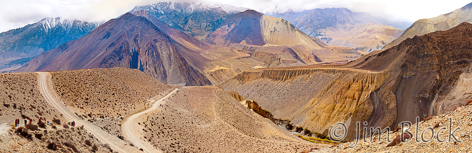
From near Khingar we could see the villages we passed through, the walls of the temple comple of Muktinath Mandir, and route to Thorung La in the distance on the far right of the panoramic image below.
You can click this image to get to a site where you can zoom way in then pan around. When you get there, click the double arrow above the image on the right to see it full frame. Please wait for the resolution to download. You can use the + and – keys to zoom and the arrow keys to scroll. Or use the scroll wheel to zoom and the left mouse to drag.
Once you have zoomed and scrolled, Muktinath is the village on the right side of the panorama with the red roof in the left side of the village. Above Muktinath you can see a temple. To the left of the temple is the wall of the ringed complex of Muktinath Mandir. Above and a bit to the left of the wall is the route to Thorung La.
")
We followed the deep Jhong Khola river valley, seeing the parched hills of Upper Mustang across it. Both are obvious in the center of the photo above and in the photos below. Upper Mustang is a forbidden province – you need special permission and extra money to visit.
")

")
Along the way we saw hundreds of pilgrims, some with bare feet, making their way to the temples at Muktinath. Many jeeps transporting other pilgrims, who were wealthy enough to afford a ride up to the temples, also passed us as we descended to Kagbeni.

")
The scenery became even more spectacular as we neared Kagbeni. We began to see green in the fertile river valleys where two rivers come together; the Kali Gangaki being fed by the smaller Jhong Khola. We saw many apple orchards, although it was too early in the season for the trees to be in bloom.

")

Kagbeni is a charming, beautiful old city and one of the principal gateways to Upper Mustang. It was the dominant hub of the salt trade from Tibet before the 1850s. The passes across the Himalaya north of Kagbeni are relatively lower than other passes from Tibet to Nepal.

We stopped at a teahouse where our Sherpas quickly became good friends with the beautiful and charming young woman who made us some tea. Leaving our packs and trekking poles in that teahouse, we toured the city of Kagbeni.

One of the first restaurants to greet us was a “Yak Donalds”. We made our way through narrow stone-wall-lined passages, visited an old temple, and photographed some interesting sculptures.


At the northern part of town, we reached the spot where we could go no farther—the entrance to Upper Mustang.
-")

Leaving Kagbeni, we traveled down the Kali Gangaki river valley to a small village of Eklebhatti. Eklebhatti means “one tea house”, though it now has more than one. There we had a late lunch in a tea house by the trail. Lisa was our “dal bhat queen”, and I rarely touched it. However, Chhongba ordered dal bhat all around knowing it was very good here. And it was, as was the potato curry.
As I started to eat the green salad Milt asked, “are you going to eat that?”. Green salads are generally avoided in Nepal because the vegetables are often washed with unclean water that can make you very sick. I looked at Chhongba, “is it okay to eat this?” He replied in his characteristic, “I think so”, which I took to mean yes. I certainly trust Chhongba – he is very good at keeping us healthy – so I dug into the green salad. I believe I was the only one to eat it, except for Chhongba.


Below Eklebhatti the drama of the stark landscape continued. Before Jomsom a strange series of walls, a maze perhaps, appeared across the Kali Gangaki. It’s white in the bottom center of the photo to the right below.


We spent two nights in Jomsom where we would catch a plane to Pokhara. There I’ve photographed children chasing hoops propelled by a bent wire. That evening we said goodbye to our porters and two of our sherpas with a slightly-wild end-of-trek celebration party in the basement of our lodge.


A slide show follows with additional images from our walk from Muktinath to Jomsom.


")
")


")


")


")
")


")
")
")


")


")


![]()